Carte de la Floride Occidentale et Louisiane, 1777 map
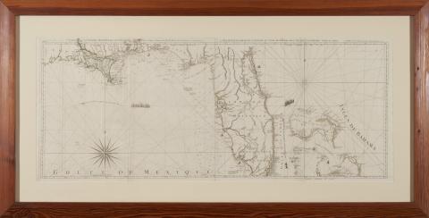
Carte de la Floride Occidentale et Louisiane with La Peninsule et Golfe de la Floride ou Canal de Bahama avec Les Isles de Bahama by Thomas Jefferys (Paris: Chez Le Rouge, 1777), two sheets, outline color, presented in heart pine frame, overall dimensions 29 x 58 inches.
Description: Map page leaf from "Atlas Ameriquain Septentional" published by Georges–Louis Le Rouge that features Southern Louisiana, Florida, and the Bahamas
This set of maps can likely be traced to antebellum Georgia attorney Mitchell King, whose papers are archived at The University of North Carolina, Chapel Hill.
The German-born George-Louis Le Rouge published these maps in Paris at a time when France renewed its active participation in American affairs. The maps meticulously show a rugged North American landscape between Canada and the Gulf of Mexico with details that would aid travelers – and armies - of that era. Accordingly, the Le Rouge maps became highly prized by strategists on both sides of the American Revolution. All plates in the Atlas are copperplate engravings of the period.
Contact us for information about accessing a higher resolution copy