Center for Louisiana Studies Archival Catalog
This searchable database provides information on images, documents, and audio and video recordings, made between 1934 and the present.
Le Fleuve Saint-Laurent map, 1755
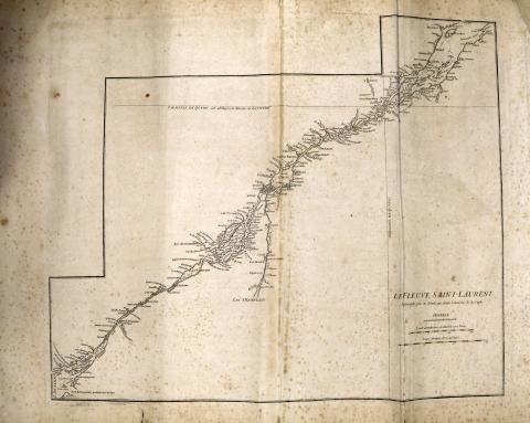
"Le fleuve Saint-Laurent: represente plus en detail que dans l'etendue de la carte", plate from the Atlas of America; 1755.
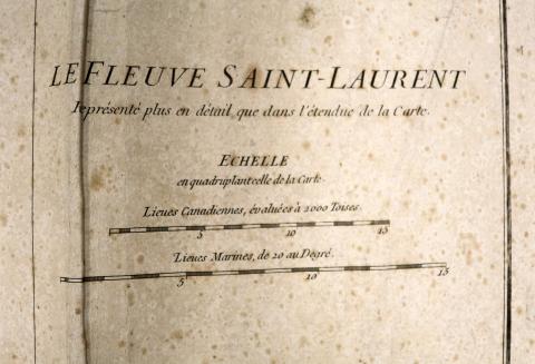
Detail of "Le fleuve Saint-Laurent" map, 1755
Plan of the River of Annapolis, Royal in Nova Scotia, 1757
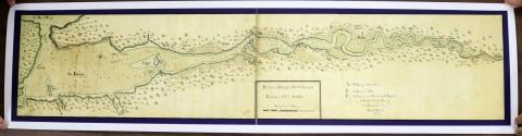
Plan of the River of Annapolis, Royal in Nova Scotia, map reprint, 1757
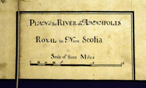
Detail of Plan of the River of Annapolis, 1757
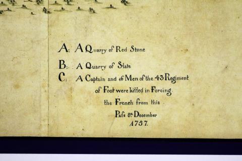
Detail 2 of Plan of the River of Annapolis, 1757
Amerique Septentrionale, 1777 map
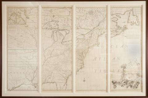
Amerique Septentrionale by John Mitchell (Paris: Chez Le Rouge, 1777), Third edition, fourth impression, with outline color and in four vertical sections, each being 54 x 18-3/4 inches.
Description: "Atlas Ameriquain Septentional" map published by Georges–Louis Le Rouge
This set of maps can likely be traced to antebellum Georgia attorney Mitchell King, whose papers are archived at The University of North Carolina, Chapel Hill.
The German-born George-Louis Le Rouge published these maps in Paris at a time when France renewed its active participation in American affairs. The maps meticulously show a rugged North American landscape between Canada and the Gulf of Mexico with details that would aid travelers – and armies - of that era. Accordingly, the Le Rouge maps became highly prized by strategists on both sides of the American Revolution. All plates in the Atlas are copperplate engravings of the period.
Contact us for information about accessing a higher resolution copy
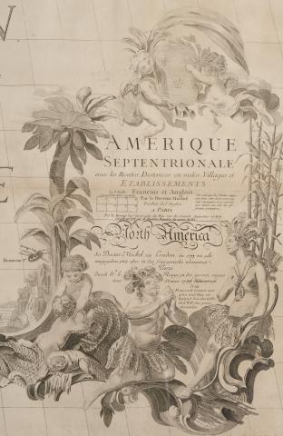
Detail of Amerique Septentrionale
The German-born George-Louis Le Rouge published these maps in Paris at a time when France renewed its active participation in American affairs. The maps meticulously show a rugged North American landscape between Canada and the Gulf of Mexico with details that would aid travelers – and armies - of that era. Accordingly, the Le Rouge maps became highly prized by strategists on both sides of the American Revolution. All plates in the Atlas are copperplate engravings of the period.
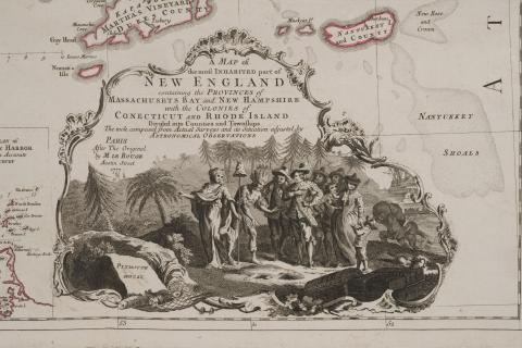
A Map of the Most Inhabited Part of New England, 1777
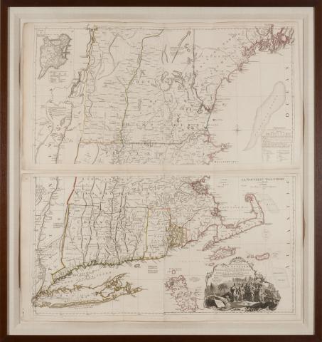
A Map of the Most Inhabited Part of New England (Paris: Chez Le Rouge, 1777), John Green and Braddock Mead, two sheets with outline color, presented together in wooden frame, overall dimensions 49 x 46 inches.
This set of maps can likely be traced to antebellum Georgia attorney Mitchell King, whose papers are archived at The University of North Carolina, Chapel Hill.
The German-born George-Louis Le Rouge published these maps in Paris at a time when France renewed its active participation in American affairs. The maps meticulously show a rugged North American landscape between Canada and the Gulf of Mexico with details that would aid travelers – and armies - of that era. Accordingly, the Le Rouge maps became highly prized by strategists on both sides of the American Revolution. All plates in the Atlas are copperplate engravings of the period.
Contact us for information about accessing a higher resolution copy
Detail of A Map of the Most Inhabited Part of New England, 1777.
Virginie, Maryland map, 1777
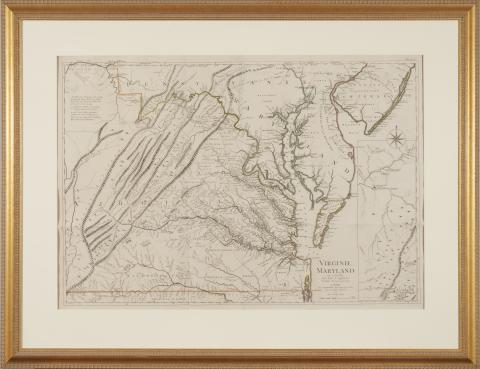
Virginie, Maryland map by Joshua Fry and Peter Jefferson (Paris: Chez Le Rouge, 1777), outline color, presented in gilt wooden frame, overall dimensions 40 x 54 inches.
This set of maps can likely be traced to antebellum Georgia attorney Mitchell King, whose papers are archived at The University of North Carolina, Chapel Hill.
The German-born George-Louis Le Rouge published these maps in Paris at a time when France renewed its active participation in American affairs. The maps meticulously show a rugged North American landscape between Canada and the Gulf of Mexico with details that would aid travelers – and armies - of that era. Accordingly, the Le Rouge maps became highly prized by strategists on both sides of the American Revolution. All plates in the Atlas are copperplate engravings of the period.
Contact us for information about accessing a higher resolution copy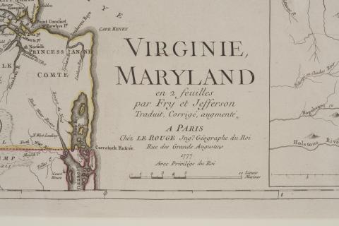
Detail of Virgnie, Maryland map, 1777
Le Guadeloupe map, 1753
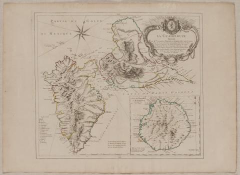
Le Guadeloupe map (Paris, Chez Le Rouge, 1753), both maps with outline color and presented together in a wooden frame, overall dimensions 45-1/2 x 35 inches
This set of maps can likely be traced to antebellum Georgia attorney Mitchell King, whose papers are archived at The University of North Carolina, Chapel Hill.
The German-born George-Louis Le Rouge published these maps in Paris at a time when France renewed its active participation in American affairs. The maps meticulously show a rugged North American landscape between Canada and the Gulf of Mexico with details that would aid travelers – and armies - of that era. Accordingly, the Le Rouge maps became highly prized by strategists on both sides of the American Revolution. All plates in the Atlas are copperplate engravings of the period.
Contact us for information about accessing a higher resolution copy
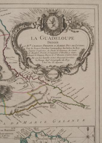
Detail of Le Guadeloupe map, 1753
Province de New York, map, 1777
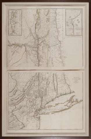
Province de New York (Paris: Chez Le Rouge, 1777), two sheets with outline color, wooden frame, overall dimensions 67 x 43-3/4 inches.
This set of maps can likely be traced to antebellum Georgia attorney Mitchell King, whose papers are archived at The University of North Carolina, Chapel Hill.
The German-born George-Louis Le Rouge published these maps in Paris at a time when France renewed its active participation in American affairs. The maps meticulously show a rugged North American landscape between Canada and the Gulf of Mexico with details that would aid travelers – and armies - of that era. Accordingly, the Le Rouge maps became highly prized by strategists on both sides of the American Revolution. All plates in the Atlas are copperplate engravings of the period.
Contact us for information about accessing a higher resolution copy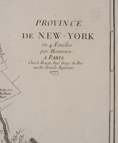
Detail of Province de New York map, 1777
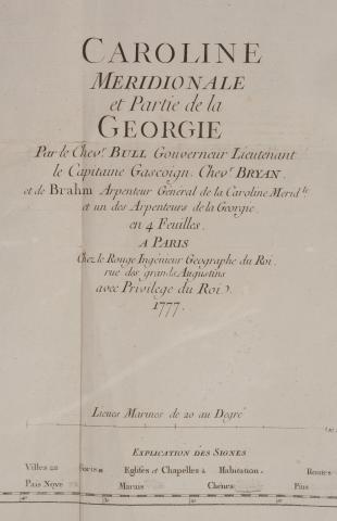
Caroline Meridionale et Partie de la Georgie map, 1777
Caroline Meridionale et Partie de la Georgie by William Gerard de Brahm (Paris: Chez Le Rouge 1777), on four sheets, the lower half with an inset map by Sauthier showing the course of the Hudson River, hand color, presented in wooden frame, overall dimensions 48-1/4 x 56 inches.
This set of maps can likely be traced to antebellum Georgia attorney Mitchell King, whose papers are archived at The University of North Carolina, Chapel Hill.
The German-born George-Louis Le Rouge published these maps in Paris at a time when France renewed its active participation in American affairs. The maps meticulously show a rugged North American landscape between Canada and the Gulf of Mexico with details that would aid travelers – and armies - of that era. Accordingly, the Le Rouge maps became highly prized by strategists on both sides of the American Revolution. All plates in the Atlas are copperplate engravings of the period.
Contact us for information about accessing a higher resolution copy
Detail of Caroline Meridionale et Partie de la Georgie map, 1777.
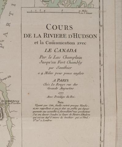
Detail of Caroline Meridionale et Partie de la Georgie map, 1777.
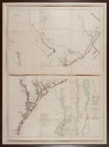
An Accurate Map of North and South Carolina, 1777
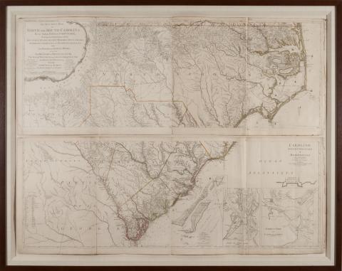
An Accurate Map of North and South Carolina by Henry Mouzon & Others (Paris: Chez Le Rouge, 1777), four sheets, outline color, presented in wooden frame, overall dimensions 49 x 62 inches.
This set of maps can likely be traced to antebellum Georgia attorney Mitchell King, whose papers are archived at The University of North Carolina, Chapel Hill.
The German-born George-Louis Le Rouge published these maps in Paris at a time when France renewed its active participation in American affairs. The maps meticulously show a rugged North American landscape between Canada and the Gulf of Mexico with details that would aid travelers – and armies - of that era. Accordingly, the Le Rouge maps became highly prized by strategists on both sides of the American Revolution. All plates in the Atlas are copperplate engravings of the period.
Contact us for information about accessing a higher resolution copy
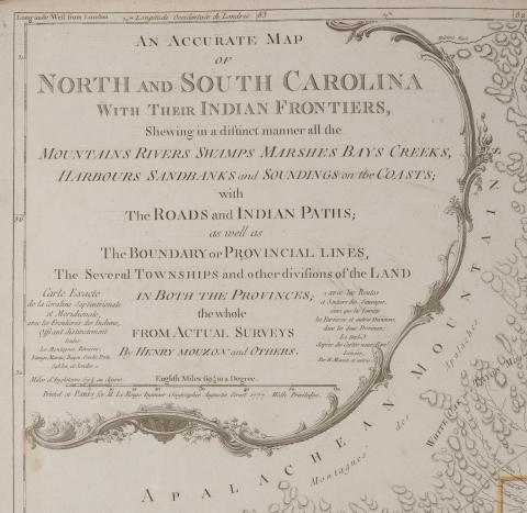
Detail of An Accurate Map of North and South Carolina by Henry Mouzon & Others, 1777
A Map of Pennsylvania or La Pensilvanie, 1778
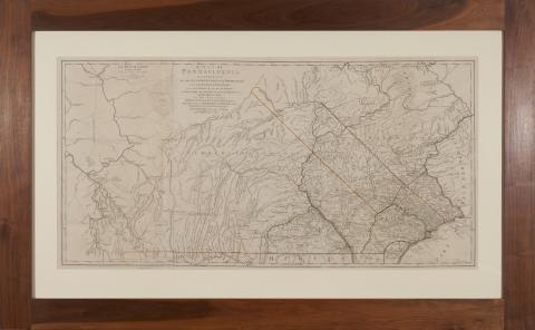
A Map of Pennsylvania or La Pensilvanie by William Scull (Paris: Chez Le Rouge, 1778), outline color, presented in walnut frame, in three parts, overall dimensions 43 x 68 inches.
Originally included in Atlas Ameriquain Septentional published by Georges–Louis Le Rouge. The German-born George-Louis Le Rouge published these maps in Paris at a time when France renewed its active participation in American affairs. The maps meticulously show a rugged North American landscape between Canada and the Gulf of Mexico with details that would aid travelers – and armies - of that era. Accordingly, the Le Rouge maps became highly prized by strategists on both sides of the American Revolution. All plates in the Atlas are copperplate engravings of the period.
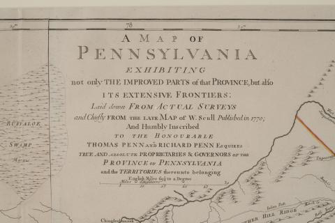
Detail of A Map of Pennsylvania or La Pensilvanie by William Scull, 1778
La Martinique map, 1753
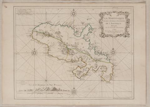
La Martinique map (Paris, Chez Le Rouge, 1753), map with outline color in a wooden frame, overall dimensions 45-1/2 x 35 in.
This set of maps can likely be traced to antebellum Georgia attorney Mitchell King, whose papers are archived at The University of North Carolina, Chapel Hill.
The German-born George-Louis Le Rouge published these maps in Paris at a time when France renewed its active participation in American affairs. The maps meticulously show a rugged North American landscape between Canada and the Gulf of Mexico with details that would aid travelers – and armies - of that era. Accordingly, the Le Rouge maps became highly prized by strategists on both sides of the American Revolution. All plates in the Atlas are copperplate engravings of the period.
Contact us for information about accessing a higher resolution copy
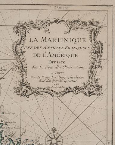
Detail of La Martinique map, 1753.
Baye de la Delaware map, 1777
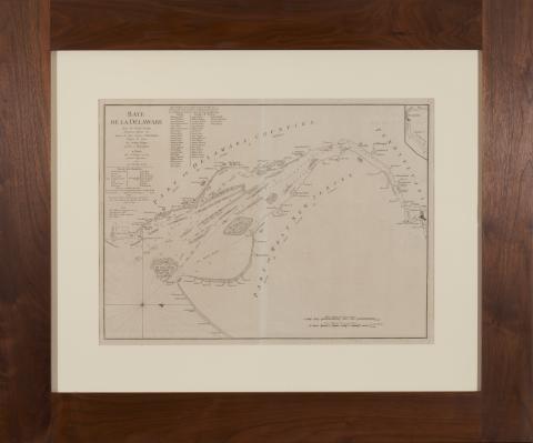
Baye de la Delaware by Joshua Fisher (Paris: Chez Le Rouge, 1777), presented in walnut frame, overall dimensions 34-1/2 x 41-1/2 inches.
This set of maps from the Atlas Ameriquain Septentional was purchased by the present owner from William Nash Rare Books in Atlanta, Georgia in the 1980s. It was previously acquired from the King family of the Atlanta-based King & Spalding law firm and can likely be traced to antebellum Georgiaattorney Mitchell King, whose papers are archived at The University of North Carolina, Chapel Hill.
The German-born George-Louis Le Rouge published these maps in Paris at a time when France renewed its active participation in American affairs. The maps meticulously show a rugged North American landscape between Canada and the Gulf of Mexico with details that would aid travelers – and armies - of that era. Accordingly, the Le Rouge maps became highly prized by strategists on both sides
of the American Revolution.
All plates in the Atlas are copperplate engravings of the period.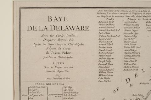
Details of Baye de la Delaware map, 1777.